The next post is about rain gardens and ponds and is where habitat, hydrology and stormwater management start to overlap. This is a paper I wrote about the hydrologic cycle that may be helpful to anyone wanting to understand hydrology and why it’s so important that we mitigate the affects of all of our impervious surfaces.
The Hydrologic Cycle: Focus on the Oregon Cascades
 The Importance of Water
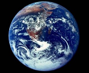
In water, life on earth began and all life now depends on water for survival. Without water animals would perish, plants would wilt and we would cease to be the blue planet. On Earth, water is life. Water plays more of a role than just keeping the beings on the planet alive, it is also home to 90% of all organisms. (Lee p. 5) It carries nutrients, cleanses animals internally as well as externally, and is required in photosynthesis. The water, or hydrologic, cycle makes all this possible.
Natural History
Natural history in the United States shows a few key points in the shaping of our landscape. First are the beavers that shaped much of the land across the country by building dams. The Europeans new to the country discovered a huge population of beavers, which was quite exciting because they had nearly wiped out all of their own. The Europeans wiped out millions of beavers thus affecting the ecosystem drastically. Dams were destroyed, ponds lost and the waterways altered. “Beavers do more to shape their landscape than any other mammal except human beings…” (Outwater, p. 20) As a keystone species they create wetlands, meadows and habitat for many animals and insects. They are ‘nature’s hydrologists’.
The second key point in shaping our landscape was the loss of forests. The early settlers viewed the woods as “mysterious and frightening”. (Outwater, p. 36) They also didn’t recognize the importance of the forests in the hydrologic cycle. Without the trees the soil erodes, water is absorbed less and more silt drains into streams. “It is estimated that about half the contiguous United States was once old-growth forest…” (Outwater, p. 37) As the forests were cut down, fields replaced them. The native practice of burning was abandoned as well, which drastically altered the woodlands. Boars were introduced and altered the habitat further.
Forest Influences
Forests provide shade which moderates temperatures on the land and in the waterways. They protect against wind, intercept rain and snow with leaves and needles, reduce runoff and erosion and increase humidity. In addition more organic matter is created and water quality is better.
The Water Cycle
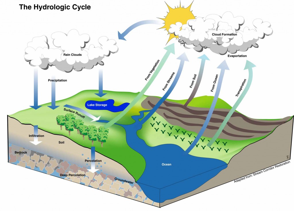
The hydrologic cycle is in short, the “continuous circulation of water from the sea to the atmosphere to the land and back again to the sea”. (Manning, p. 2) Water evaporates from the ocean and is transported to clouds. Precipitation brings the water down to the ground where it either infiltrates into the ground or runs off. If it infiltrates it goes into a water table and joins the ground water flow. If it runs off it collects in waterways where it then flows or evaporates back into the air. Plants that take up the ground water then lose it through evapotranspiration.
There are approximately 1.4 billion cubic kilometers of water on the earth, fresh water being only 2.6% of that, which equates to about 36 million cubic kilometers. (Pielou, p. 2) About 98% of all earth’s water is in liquid form, while about 2% is in solid form and only .001% is in gaseous form. In freshwater, over 77% is in solid form while only 22% is in liquid form and .04% in gaseous form.
“…water is by far the most visible of moving entities on earth; consider, e.g., clouds, precipitation, streams, ocean waves, waterfalls, avalanches and geysers.” (Lee, p. 2)
Properties of Water
Forms
Water exists in three possible forms, solid, liquid and gaseous. It is composed of two hydrogen molecules and one oxygen molecule. The majority of sea water is liquid while the majority of fresh water is in solid form. As it heats and cools, water actually shrinks and expands and can increase around 9% in volume when converted to a solid state from liquid. (Manning, p. 9) Water in a solid form, snow pack and ice can act as an insulator keeping the soil above freezing level.
Thermal Properties
Boiling point for water is 212° F (100° C) and freezing point is 32° F (0° C). Water has a very high heat capacity thanks to its hydrogen bonding capabilities which leads to vaporization. In this process the hydrogen bonds start to break and as a result water escapes as gas, or water vapor. This can eventually condense and rise up into the sky to form clouds.
Viscosity is another thermal property that affects how water flows depending on its temperature. Think of the way water moves through different sized irrigation pipes and the friction that is caused. An increase in temperature will decrease viscosity and increase flow. (Manning, p. 15)
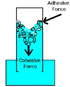 Surface tension is another affect of hydrogen bonding, but now mixed with the air the molecules draw inward creating more tension. “Because of hydrogen bonding the surface tension of water is two or three times higher than that of most common liquids.” (Manning, p. 16)
Capillarity combines cohesion (water molecules attracted to water molecules) and adhesion (water molecules attracted to soil particles) which results in a drawing up of water. In soil, smaller pores provide greater movement, the pores act as capillaries. “Liquid rises to the point where gravity balances the adhesive and cohesive forces.” (Plaster, p. 107) As soil dries, capillarity causes water to rise up and can eventually evaporate back into the air. This is more likely where there’s a higher water table present.
Water can also act as a solvent by separating molecules in some elements. It also holds compounds that are taken up by plants and animals. Water can dissolve most anything and “only a few natural substances will not dissolve in water”. (Manning, p. 18)
Atmospheric Water
Evaporation
A major link in the water cycle is the movement of water back into the atmosphere; evaporation takes care of that link. Evaporation is “changing visible water into invisible vapor” (Manning, p. 21) ”More precipitation is disposed of through evaporation than through streamflow and storage combined.” (Hewlett, p. 66) Water can evaporate from many different sources including surfaces such as lakes and rivers. It can also evaporate from soil and vegetation although in highly vegetated areas the rate of evaporation from the soil is much less than in arid or less vegetated locations. Water is evaporated from vegetation by transpiration as well as intercepted precipitation the collects on plants surfaces.
Water vapor contained in the air is finite, and the limit is called saturation humidity. The total amount of water vapor in the air is referred to as absolute humidity. Depending on the temperature, the saturation humidity can vary; warmer air has a higher absolute humidity than cooler air. Basically warmer air holds more water. Dew point is the temperature at which the saturation humidity is reached. “Water vapor rises from ice as well as from liquid water, in a form of evaporation known as sublimation.” (Pielou, p. 239)
Water molecules must escape the bond before they can move into the atmosphere. The gas molecules are more distant from neighbor molecules, which expands the water and causes the hydrogen bonds to be much less strong than in the liquid form.
Condensation
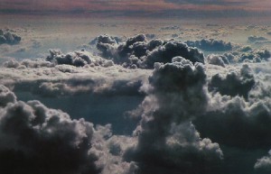 Condensation is the opposite of evaporation and is the change of water vapor into liquid water. Evaporation and condensation are linked in an energy equilibrium. As water evaporates it acquires energy or heat and when vapor condensates, it releases energy and that amount of energy is balanced equally between the two transformations.
The dew point is again referred to with condensation. The air which contains the water vapor must be cooled to saturation humidity and then the vapor can condensate on surfaces. This is how clouds and fog are formed. Instead of condensing on a surface, the vapor forms a cloud with many droplets of water. The temperature warming above the dew point causes clouds and fog to dissipate.
Transpiration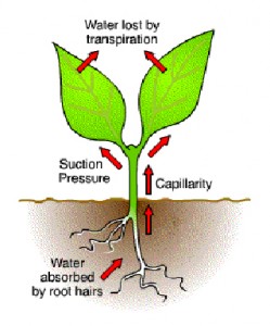
Plants take up water through their roots which later escapes into the air from stomata, tiny holes in a leaf. This process is called transpiration. Nearly 98% of the water taken in from the roots is lost in transpiration. (Capon, p. 142) The water that escapes is not in liquid form, but instead is released as water vapor. The amount that plants transpire is not minute, “a single, 48-ft. Silver Maple is estimated to transpire as much as 58 gallons per hour”. (Capon, p. 142) This process can be stopped by the plants if they close their stomata when water to the roots is in short supply.
There are factors that affect the transpiration rate such as dry or wet air, temperature, and wind. Dry air will cause the plant to close its stomata because the transpiration rate will increase. Wind will also cause the stomata to close because the moisture from the plant can be drawn out.
Evapotranspiration
The combination of evaporation and transpiration equals evapotranspiration. This measures the transpiration of plants, the evaporation of water from the soil and evaporation of water intercepted by plant surfaces. It all combines to a hefty amount and is estimated that evapotranspiration returns 2/3 precipitation back into the air.
Precipitation
Cascades Weather
The Oregon Cascades are an incredibly dominant part of the terrain and influence the weather greatly. The Three Sisters area is one of the highest in the state at over 10,000 feet. Because the Cascades are so dominant and run north to south the length of the state, they affect the weather for the entire east side of the state by decreasing the precipitation to 12” a year or less. Due to the height of the Cascades, the storms must rise up when they meet the mountains and that causes high amounts of precipitation. Varying on the elevation, the Cascades can range anywhere from 80 to 150 inches of precipitation annually, a large percentage of that in the form of snow instead of rain. Most of those inches come in the winter months. The yearly mean precipitation for McKenzie Bridge is 67.88 inches while Government Camp’s yearly mean precipitation is 86.03. (Taylor and Hannen, p. 64) McKenzie Bridge only has four months of non-freezing weather, from the end of May to early September, or an average of 126 days between freeze level temperatures. (Taylor and Hannen, p. 64)
Process
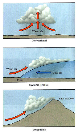
After condensation creates the clouds, the tiny droplets form into larger drops that become either rain or snow. When the temperature is below freezing, the droplets crystallize to form snow or ice. The majority of the water in the atmosphere comes not from the land, but from the sea. “Precipitation occurs when large masses of moist air have steadily moved aloft either due to convectional rise, or to invading warm or cold air masses that slide over or under one another, or due to forced rise over land obstructions.” (Hewlett, p. 29)
 Types
Types
There are three different types of storm events.
The first are convectional storms which are “caused by differential solar heating of the ground and lower air layers…” (Hewlett, p. 29) Convection is the moving of heat. Think of oatmeal boiling, as it heats up it moves to the surface where it cools and is cycled back around the sides to be heated again. That’s what happens to the air when it’s warmer than the surrounding areas. As it rises, it goes through the process of condensation and creates clouds. This type of storm is how most thunderstorms are produced and is due mostly to the sun heating the ground unevenly.
The second storms are frontal or cyclonic storms which are “caused by warm air invading cold air, or cold air invading warm”. (Hewlett, p. 29) The warm or cold air is in large masses many miles in size. Fronts are the area between the two masses.
And the third are orographic storms which are “caused by moist air riding over a topographic barrier…” (Hewlett, p. 29) They often occur with one of the other two types of precipitation. The location of this type of storm is usually the side of mountains that receive the wind.
Forms
Precipitation leaves clouds in many different forms. Dew, frost and fog are not considered precipitation because they form by condensation.
Rain is the most well known form of precipitation and as a standard consists of droplets that average 1 millimeter in size. Raindrops form from the condensation and when they get too large to remain suspended, they fall.
Snow dominates in the high mountains as the main form of precipitation. Snow forms in the clouds in freezing weather as ice crystals which usually group together to form a snowflake. The size of each may vary.
Drizzle is droplets that are smaller than rain but larger than fog, somewhere between 0.1 and 0.5 millimieters.
Sleet is rain that has been frozen after it left the cloud.
Hail can vary greatly in size from 5 centimeters to over 4 inches in diameter. It’s formed by updrafts after leaving the cloud, occurring during convectional storms. The ice builds up while in the sky but never falls when the temperature on the ground is freezing.
Snow
“About 75% of western U.S. water supplies come from forests and wildlands, much in the form of snow.” (Hewlett, p. 39) Although snow is considered precipitation, it varies greatly in the role it plays on the ground from rain. Instead of contributing to the water cycle immediately, it has a more lingering affect. It acts as a natural reservoir. Snow melts in the spring, but very little water escapes from evaporation and the water can be stored for much longer. The snow of the Cascades is dense and wet which is not favorable for sublimation, which is the snow converting to vapor. When it does melt, it runs off and raises water levels in streams and rivers sometimes drastically. Some of the snowmelt is infiltrated into the soil as well. Snow can melt by heat from the sun, the rain or warmth from the soil.
Disposal
When precipitation falls, there are many routes in can take in the water cycle.
Interception occurs when precipitation lands on vegetation. Some of the water can be held in the canopy until it evaporates back into the air, some can be directed by the leaves down to the soil and to the roots, and some can be used for aerial plants. The majority of the precipitation is caught at the beginning of a storm event. Forests can intercept 10%-20% of annual rainfall while in short storms as much as 80% can be intercepted. The benefit of interception is that as the raindrops hit the leaves, the water that falls through is broken down into smaller droplets and hits the soil less hard. This helps keep the pores unclogged, infiltration high and runoff low.
The water that isn’t intercepted falls though to the earth’s surface where it can land on the soil, in bodies of water or in moving water.
Surface Water
Runoff
Water that is not intercepted ends up on the ground and what doesn’t enter the ground takes another trip and runs to lakes, rivers or streams. In the early part of a storm, most of the water is either intercepted and evaporates or infiltrates into the ground. Runoff gathers pace when the vegetation can’t hold any more rainfall and the ground reaches its saturation point and can’t support any more water. The excess water travels across the soil to streams or lakes causing the levels to rise.
 There are several factors that affect the amount of runoff. The first is the climate which determines how much precipitation an area will experience. The amount of precipitation in conjunction with the frequency will greatly affect runoff. More frequent storms don’t give the soil a chance to dry out and increases the runoff. The Oregon Cascades receive a lot of precipitation, however a large portion is in snow. Snow changes the runoff because it builds up on the ground for many months. “Snow falling on unfrozen ground will form an insulating blanket and prevent freezing of the soil. Then when melting begins in the spring, some of the resulting water will infiltrate the soil surface, slowing the runoff process. On the other hand, snow on frozen ground also insulates the surface and prevents early thawing of the soil.” (Manning, p. 176) When the snow does thaw, because the ground is frozen the water can’t infiltrate and runs off causing waterways to rise very quickly.
Physical characteristics also affect runoff. The lay of the land or topography is naturally going to affect runoff because of slopes. Steeper slopes will increase the speed of the runoff. Vegetation affects runoff by the amount it intercepts as well as the amount it draws out of the soil and thus causes more infiltration. The cover also slows the water giving more time for infiltration. Soil type also has an affect on the amount of runoff because it dictates the infiltration rate.
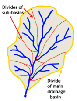
Geologic factors greatly determine runoff as well. Those factors influence the drainage basin, create drainage patterns, encourage the erosion process and impact storage time.
Erosion
 Rain causes erosion. “Erosion is the process by which soil and minerals are detached and transported by water, wind, gravity, ice and man’s activities.” (Hewlett, p. 135) There are a number of types of erosion, the first being mass wastage which consists of erosion from gravity that results in landslides, mudflows and other land moving. Soil can also erode from rainfall striking and breaking the particles apart. Moving water picking up particles and displacing them also causes erosion. In cold areas, freezing and thawing can also break apart soil particles making them easier to move.
Erosion can form tiny gullies, called rills, causing water to move faster and pick up more soil. It can also form large gullies that increase the erosion with the increase of the water flow. As the erosion increases so does the steepness of the slope.
Erosion causes a loss of topsoil which is where most roots live. The topsoil also contains most of the nutrients and organic matter. Erosion also thins the soil profile of the topsoil which decreases the depth for roots. Sediment taken from erosion washes into moving water and lakes and is deposited there.
Lakes, Rivers and Streams
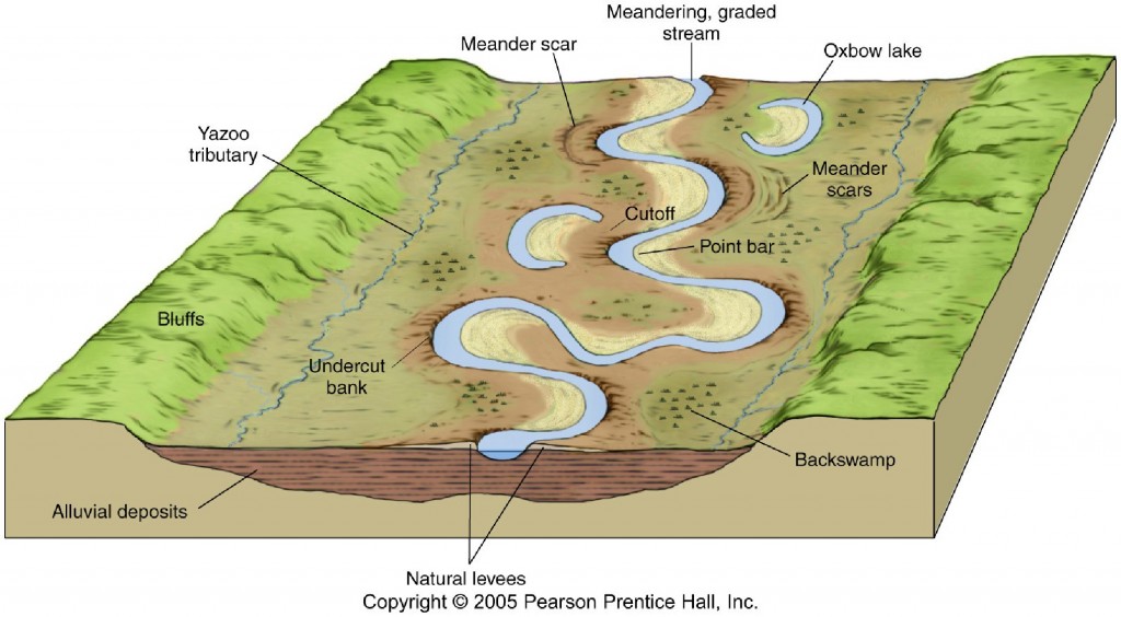
Channels form from the natural forces including water and erosion. Runoff heads to channels which in turn carry the water and accompanying sediment. They are formed in a concave shape and drain into the ocean. Sediment dropped along the way is the cause for the snaking shape of stream channels. As the bends in the snaking shape get thinner from the dropped sediment, the curve becomes more extreme and eventually a new channel will form cutting off the bend and creating an oxbow lake. Channels and lakes are constantly changing, new channels and lakes form while existing ones disappear.
 The area in the Oregon Cascades, “from South Sister to Mt. Jefferson…are home to over 300 lakes”. (Hatton, p. 14) They are relatively short term features in the landscapes as they are slowly filled in by sediment or drained by changes in the landscape. All in this area were formed by volcanic activity or glaciers, the majority in this area forming as a result of the latter.
Floodplains and Floods
Floodplains are the area bordering channels that are built up from sediment carried by runoff. During heavy rain periods they may contain overflow from the stream channels. “In truth, the floodplain is simply the high-water phase and the so-called channel is the low-water phase of this flow system.” (Manning, p. 200)
There are five different kinds of floods. Long rain floods consist of a continual, but low rainfall over many days. Snowmelt floods come when the snowpack melts rapidly. Flash floods occur with high rainfall in a short amount of time. Frozen soil floods occur when snowmelt and rainfall can’t infiltrate due to frozen soil. Tidal floods occur in coastal ranges and are associated with the ocean.
Forest cover affects flooding in several ways, the first being that it helps hold soil in place. Forests also provide a higher water storage potential because of a high level of evapotranspiration due to the amount of vegetation. Natural forest areas have a higher infiltration rate than disturbed areas.
 Subsurface Water
Infiltration
Infiltration is the movement of surface water into the ground. The largest factor for infiltration is the soil. Soil is formed from rock that’s been broken down. It is one of many layers in the earth, and is called the ‘A horizon’. It contains the best growing layer for plants therefore that is where roots live. Above the A horizon is the O horizon which consists of an organic layer of debris. There are many types of soil ranging from clay to sand and many in between. The soil property varies depending on the type of soil. Clay has very small particles while sand has very large which means that sand has much higher infiltration. The soil type also determines porosity, which is how much of the soil contains air and water as well as permeability which is how easily water can move through the soil. Compacted soil reduces porosity and permeability which in turn can reduce the infiltration rate. Raindrops and animals both add to the compaction of soil.
When the rain falls, or the first snow melts, “molecular forces draw water into the soil”. (Manning, p. 77) The hydrogen bonds that hold water together are now used to connect to the soil particles and draw the water in until gravity takes over pulling it down further. When the soil is filled with water, it reaches its saturation point, “on level land, once it’s saturated, the infiltration rate is limited by the rate of subsurface flow, or percolation, through less permeable of underlying rock; but on sloping land, as the percolating water encounters greater resistance to flow in the vertical direction, it is diverted laterally within more permeable soil layers”. (Lee, p. 131) Water can move up as well due to forces such as adhesion and cohesion as described in the introduction. Capillarity utilizes those forces to draw water up through the soil for plant use.
Ground Water
Water that makes it past the saturation zone then goes onto another route, it is stored underground to be used for different things later. It can be stored in spaces in rock, or it can be stored in what are called aquifers, which are underground formations. “The ground containing groundwater is known as the saturation zone, and the water’s upper surface is the water table. “Unless the water table is at ground level…there is an unsaturated zone above the water table in which the pores and cracks are only partially water-filled; they contain some air as well.” (Pielou, p. 5) The stored water flows out from the aquifers and water table to supply water for springs and streams.
Aquifers
Aquifers are porous formations that water can be stored in as well as discharged from. There are many types of aquifers created from different kinds of geologic materials such as limestone, consolidated 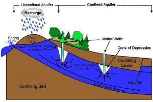 sediment, unconsolidated sediment, crystalline rock and commonly in the northwest, volcanic rock which has “distinctive systems of fractures and porous zones”. (Manning, p. 135) Aquifers can also be confined or unconfined. Confined aquifers are below an impermeable surface that creates a ceiling above them. Unconfined aquifers are beneath a water table with no impermeable surface.
Aquifers are the slowest part of the water cycle. Percolating through the ground is incredibly slow and water can be stored for a long time in the ground. A study showed in Arizona, groundwater moved on average only one foot per week.
Conclusion
The hydrologic process is simple, yet complex. The cycle of water from the sea, to the land and back again can be explained easily enough, however the small details add many subtopics to the subject of hydrology. Each region has its own characteristics that are completely its own and infinitely different. Understanding the basics of hydrology gives a solid background that can be expanded to understand more subcategories. There are an incredible amount of equations that go into measuring all the aspects of hydrology. There is book after book about each aspect of the hydrologic cycle dealing with soil, science, geology and many more. It’s a cycle that affects everything on the planet.
Hydrologic Terms
Adsorption – “Bonding of an ion or compound to a solid surface, usually temporarily.” (Plaster, p. 355)
Aquifer – “An underground formation that holds water. It is porous enough that water can flow through it to a well, so can be a source of groundwater.” (Plaster, p. 356)
Capillary rise – “Movement of water upward in the soil through soil capillaries. Occurs as soil surface dries, drawing moisture from below.” (Plaster, p. 357)
Condensation – “The change of gas to liquid.” (Manning, p. 30)
Convection – “The process of heat transfer from one place to another by the actual motion of hot liquids or gases.” (Manning, p. 43)
Drainage Basin – “A watershed that collects and discharges surface streamflow through one outlet or mouth.” (Hewlett, p. 3)
Evaporation – “Changing visible water into invisible vapor.” (Manning, p. 21)
Evapotranspiration – “The sum of water lost from oil by evaporation and transpiration.” (Plaster, p. 359)
Floodplain – “A strip of relatively smooth land bordering a stream, build of sediment carried by the stream, and overflowed regularly in times of high water.” (Manning, p. 198)
Groundwater – “Water stored underground in a saturated zone of rock, sand, gravel or other material.” (Plaster, p. 360)
Humidity – The amount of water vapor that a given volume of air can hold at any given temperature and pressure. (Manning, p. 22)
Hydrogen Bond – “Bond between two molecules in which a hydrogen of one molecule bonds to an oxygen or nitrogen of another molecule.” (Plaster, p. 361)
Hydrologic Cycle – The circular route of water from the atmosphere back to the atmosphere after it has undergone precipitation, runoff, percolation, storage, or evapotranspiration.” (Plaster, p. 361)
Hydrology – “The science dealing with the properties, distribution, and circulation of water.” (Plaster, p. 361)
Infiltration – “Downward entry of water into the soil.” (Plaster, p. 361)
Percolation – “Downward movement of water though the soil profile.” (Plaster, p. 364)
Permeability – “Ease with which gases, liquids, and plant roots plass through a specific mass of soil.” (Plaster, p. 365)
Porosity – “Percentage of soil volume not occupied by solid material.” (Plaster, p. 365)
Precipitation – “A form of water falling to earth from the atmosphere; may be in rain, snow, mist, or hail.” (Plaster, p. 365)
Runoff – “Water that falls on the soil but fails to be absorbed; flows on the surface.” (Plaster, p. 366)
Saturation – “All or most soil pores filled with water.” (Plaster, p. 366)
Silt – “Medium-sized soil separate, particles between 0.05 and 0.002 millimeter in diameter.” (Plaster, p. 367)
Soil water – “Subsurface water in the unsaturated zone between the ground surface and the water table.” (Manning, p. 84)
Surface water – “Water in natural or man-made bodies of water on earth’s surface, such as lakes or reservoirs.” (Plaster, p. 369)
Transpiration – “The evaporation of water that has passed through plants.” (Manning, p. 106)
Watershed – “The total land area in which runoff water flows into the same stream.” (Plaster, p. 370)
Water table – “Upper surface of a layer of saturated material in the soil.” (Plaster, p.370)
Wetlands – “Areas that have predominance of hydric soils that are inundated or saturated by surface water or groundwater at a frequency and duration sufficient to support, and under normal circumstances do support, a prevalence of hydrophytic vegetation typically adapted to life in saturated soil conditions.” (Plaster, p. 370)
Resources
Capon, Brian. Botany for Gardeners. Portland, OR: Timber Press, 1998.
Hatton, Raymond R. Oregon’s Sisters Country. Bend, OR: Maverick Publications, 1996.
Hewlett, John D. Principles of Forest Hydrology. Athens, GA: University of Georgia Press, 1969.
Lee, Richard. Forest Hydrology. New York, NY: Columbia University Press, 1980.
Manning, John C. Applied Principles of Hydrology. Upper Saddle River, NJ: Prentice Hall, Inc., 1997.
Outwater, Alice. Water: A Natural History. New York BasicBooks, 1996.
Pielou, E.C. Fresh Water. Chicago & London: The University of Chicago Press, 1998.
Plaster, Edward J. Soil Science and Management. Clifton Park, NY: Delmar Learning, 2003.
Taylor, George H., and Hannan, Chris. The Climate of Oregon. Corvallis, OR: Oregon State University Press, 1999.



This is a great paper, Kelly. I’m going to add your blog entry to a list of resources we are creating for further information about the water cycle.
You may be interested in the film we made at Surfrider Foundation that summarizes some of it.
You can see it here: http://www.knowyourh2o.org/
The hydrologic cycle is indeed very complex. More so than I had ever thought previously. Thanks for the information I imagine it must have taken quite a while to put this all together.
Thank you for providing this detailed and informative article on natural history and the hydrologic cycle. It’s a comprehensive overview of how water shapes our environment and ecosystems.